 This article appears in the Spring 2026 issue
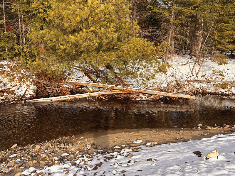
When a river bends, it erodes the outside shoreline (far side in this photo) which recruits more rocks and gravel into the stream, creates undercut banks, and topples trees into the stream. The velocity is lower on the inside bank, where the stream deposits sand and small gravel. Additional wood floating downstream, such as logs and branches, hangs up on leaning trees and creates shelter for many animals. Note healthy woodlands adjacent to the stream. Photo: Sally Harold.

Understanding
Stream Channel Complexity
By Steve Gephard and Sally Harold
We’ve all seen topographic maps and models of terrestrial landforms, but seldom do we see bathymetric maps or models of what lies below the surface. Sally remembers a National Geographic globe from her childhood that depicted the ocean floors. She imagined the many sunken boats and other treasures resting there. Decades later she’s still thinking about underwater worlds.
As equally fascinating as ocean structures are the structures created by the interplay between the land and descending water. We usually talk in this column about the fish below the surface and about providing habitat diversity for different species and different life stages. Here we explain the underlying stream structures responsible for those varied habitats.
Streams grow in size as they move downslope. Typically a network of small tributaries carries water from the uplands, joins together, and forms larger and larger streams until it empties into a receiving body of water such as Long Island Sound. The nature of the stream will be influenced by its slope and size, the material it’s passing over, and the precipitation patterns in its watershed. Steeper streams have greater energy (thanks to gravity) and can move obstacles or carve away barrier ledge. That energy also affects its ability to move streambed material. Stand next to the Ammonoosuc River in New Hampshire during snow melt and you’ll hear the rumble of rocks rolling in the current.
Streams that run across flatter terrain have less energy, cannot transport as much streambed material, and must flow around obstacles. This results in meanders and oxbows like the incredible tangle of channels you see on the Mississippi River delta and on the Connecticut River; in the Pioneer Valley around Northampton and Easthampton, Massachusetts; and below the head-of-tide in Glastonbury and Wethersfield, Connecticut.
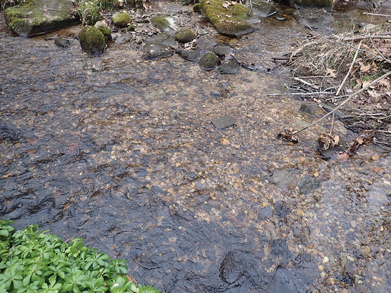
A healthy streambed has an assortment of rocks. Where velocity is strongest there are boulders and cobbles (top of photo). In areas of lower velocity smaller stone sizes such as gravel are found (middle of photo). The gravel is good spawning habitat for trout, sea lamprey, and some minnow species. Photo: Sally Harold.
The energy level also affects the nature of the streambed. Steep streams are dominated by large boulders and cobbles because the smaller-grained sediments like gravel, sand, and silt are flushed out repeatedly and transported downstream. How far? Until the energy level (i.e., velocity) of the water decreases to the point that even sand cannot stay in suspension. At that point it drops out and settles on the streambed. This is why for most of its length, the main stem Connecticut River is sandy or muddy. It has received all of the smaller-grained sediments from the steeper tributaries but lacks the energy to flush them out. Griswold Point is an ever-changing spit at the river’s mouth where fine sediment and sand drops when the river current is dulled by Long Island Sound. That does not mean that fine-grained sediment never moves—it does, but slowly and typically during high flow events. In any watershed, there are scour (erosion) areas and there are deposition areas.
Now let’s consider the medium-sized tributaries along which many of us hike, fish, canoe, swim, or birdwatch. These streams transport water, sediment, and organic matter like logs and leaves toward the Connecticut River and the ocean. Examples include the Eightmile and Jeremy rivers in Connecticut, the Green and Middle Branch Westfield rivers in Massachusetts, the White and Black rivers in Vermont, and the Ashuelot and Sugar rivers in New Hampshire. These streams cascade and run, turn and bend, and slow down and speed up in response to the topography, the activity of beaver, fallen trees, and anthropogenic structures like dams, bridges, culverts, levees, and the encroachments of homes and commercial properties, many buttressed by riprap and retaining walls.
To fully appreciate the dynamics of a stream, however, escape the developed areas and explore natural areas where streams run unfettered. As you hike along the banks of one of these streams in the spring while the trout lilies are blooming, the water is gurgling, and the warblers are singing unseen in the treetops, observe the pools where the stream current is slow and the gradient is flat. You may see trout sipping mayflies on the surface of these pools. Soon, the pool gives way to a riffle, as the water flows over a shallow gravel bed punctuated by several large boulders and the gradient steepens as the river runs downhill. If the riffle is quite large or steep, you might call it a set of rapids. In the spring the water covers the riffle from bank to bank, but by summer the water level has dropped and one end of the riffle is a dry, exposed gravel bar.
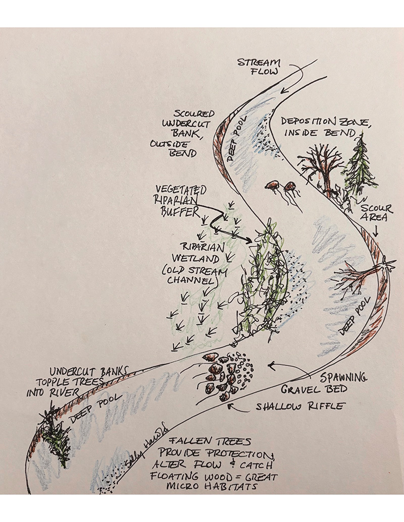
A stream channel in its natural state has many different physical features, all of which provide habitat to species ranging from aquatic insects to otters. Illustration by Sally Harold.
As the stream descends its valley and navigates an obstacle course of features, it creates bends in the river. Recall taking a sharp right turn in your car and how you feel your body tugged to the left—the outside of the curve. When a river bends right, the energy of the water goes to the left, scouring the riverbank on the outside bend (left), and depositing sediment on the inside bend (right). The scouring action may undercut trees, which subsequently fall into the stream. Some create dams over which water flows with accelerated velocity. On the downstream side of the log, the current scours a hole in the streambed. This not only creates new deep-water habitat but it sorts and cleans the substrate, sending the fine materials downstream and stockpiling the clean gravel. Some of these fallen trees catch other trees and branches flowing downstream and create such a large mass of wood that it diverts flow, often creating a braided stream—a stream with more than one channel. Islands, wetlands, and gravel bars are formed. All of this looks terribly messy, but the gravel bars are fish spawning habit; the riparian wetlands are nurseries for turtles and frogs; the undercut banks are homes for otter and mink; and the eroding riverbank hosts nests for bank swallows and kingfishers. In the tangle of woody debris, fish find protection from predators. All of these species depend upon the disruptive and “messy” dynamics that form and maintain our streams.
When the artifacts of natural stream dynamics occur near a town center or near homes, we have this unsatiable urge to “clean it up.” We pile tons of rip-rap along the river’s banks, encase the river in concrete, or even bury it in huge conduits. That may solve a localized problem, but in doing so, we create other problems upstream and downstream. The result can be downstream flooding, washed out bridges and roads, and backyards falling into the river. We err when we think of a river solely as a water conveyance channel. It is an ecosystem, and if we straighten and otherwise tame a river, we decimate that ecosystem.
There are so many places in our watershed where the natural approach to stream management is no longer possible. We have cities, interstate highways, and neighborhoods that must be protected. Much of that development is in places too close to the river, in the floodplain. We may know better than to build in these areas today, but we still have to protect what exists. When we are able to correct a past mistake by removing a dam or restoring a natural stream channel, we should do so. But we can now act smarter to avoid creating new problems. We must let streams be streams. Let rivers wander, flood, erode and fill, and tip over trees. Let us adopt a new vision of what is messy and what is beautiful in the natural world.
Steve Gephard is a fish biologist who retired from the CTDEEP and has a long association with the Connecticut River. Sally Harold has worked on dam removal and fish passage projects for over 20 years, including as Director of River Restoration and Fish Passage for the Connecticut Chapter of The Nature Conservancy. Steve and Sally collaborate on dam removals and fishway projects through RiverWork, LLC, and can be reached at Riverworkllc@gmail.com.