 This article appears in the Fall 2025 issue

Exploring the West River
Story and photos by John Burk
On a crisp October morning last fall, I followed scenic byways and back roads along the valley of the West River, the Connecticut River’s second-largest tributary in Vermont. Ascending steadily into the heart of the southern Green Mountains, the route wound past fog-shrouded hollows; steep, wooded slopes; classic New England villages; waterfalls; and covered bridges. Though some amenities were heavily damaged by flooding in 2023, there is still much to see by car, on foot, or by paddling, and one could easily spend a day or a week exploring the area.
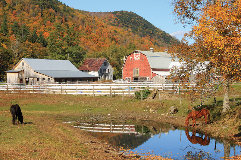
A working farm nestled below steep slopes of the West River valley on Route 30, Townshend, VT.
From headwaters in the town of Mount Holly, the West River winds forty-six miles through southeastern Vermont to its confluence with the Connecticut River at Brattleboro, dropping 2,200 feet along the way. Diverse habitats within its 423-square-mile watershed include regionally uncommon natural communities such as cobblestone shores, riverside grasslands, and sycamore floodplain forests.
The Abenaki, who inhabited the watershed for more than 12,000 years, called the river Wantastekw (“the river where something is lost”) or Wantastiquet (“waters of the lonely way”). The valley served as a crucial travel corridor between the Connecticut River and Lake Champlain. Native village settlements existed at Salmon Hole in what is now Jamaica, the Retreat Meadows in Brattleboro, and in Dummerston. At the Retreat Meadows, ancient petroglyphs on a ledge were inundated after construction of the Connecticut River’s Vernon Dam in 1909.
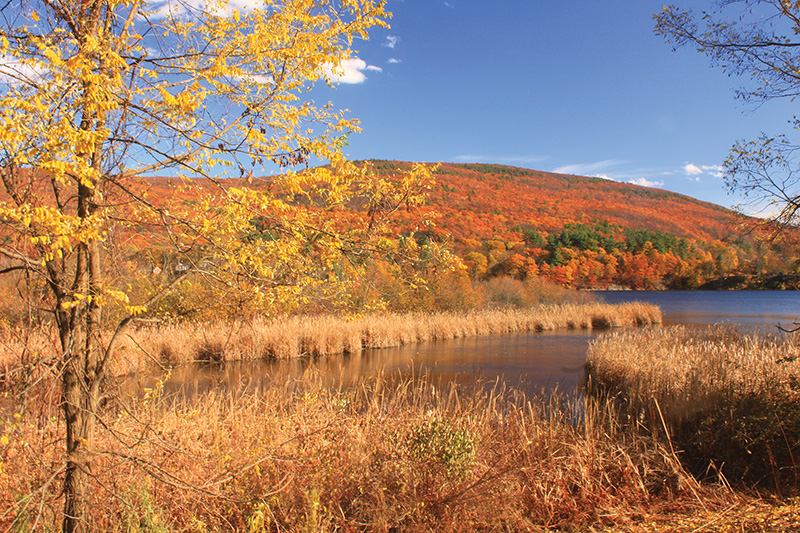
Marshy wetlands at the Retreat Meadows near the confluence of the West and Connecticut rivers, Brattleboro, VT.
Brattleboro is an ideal starting point for exploring the region, offering restaurants, shops, galleries, and breweries. One of Vermont’s historic mountain roads, Route 30, affords a scenic passage along the West River from downtown Brattleboro to Jamaica. On the south side of the river’s mouth, the aforementioned Retreat Meadows, a 55-acre marshy backwater, provides habitat for waterfowl, wading birds, shorebirds, and bald eagles, as well as quiet-water paddling, walking trails, and other recreational opportunities.
On the east banks, a 3.6-mile segment of the West River Trail follows the corridor of an abandoned narrow-gauge railroad that once linked Brattleboro to South Londonderry. Established in 1881, the railway was popularly known as “36 Miles of Trouble,” because it was continually plagued by floods, landslides, and fallen trees—issues that continue to impact the route today. Thanks to the efforts of the Friends of the West River Trail, a volunteer organization, sixteen total miles are open for hiking and other recreation.
Riverstone Preserve is the largest conservation area on the lower West River Trail corridor. It features a floodplain forest, riverside grasslands, and calcium-rich bedrock that supplies abundant nutrients to plants. In 2024 a generous land donation expanded the property to 188 acres, including more than a mile of river frontage. A recently established parking area at the end of Fox Farms Road provides access to nearly two miles of upland trails.
Black Mountain, upriver in the foothills of West Dummerston, is a 1,280-foot granite dome looming above the east banks. It originally formed as molten rock nearly 400 million years ago. A regionally rare natural community of pitch pine, scrub oak, blueberry, and huckleberry—species adapted to harsh environments—grows atop the dry summit ridge. Views extend to Mount Monadnock and the Connecticut River valley. Ancient floodplain terraces mark the historic course of the West River and former shoreline of glacial Lake Hitchcock, which inundated the Connecticut River valley after the last ice age. Several quarries thrived on the mountain in the late-nineteenth and early-twentieth centuries.
Managed by the Nature Conservancy, the 952-acre preserve has two hiking trails, including a 1.5-mile direct route to the summit, that form a 5.4-mile loop.
Workers used Black Mountain granite to construct the supports and abutments of the West Dummerston Covered Bridge, one of the valley’s familiar landmarks. The original structure, built in 1872, replaced a bridge that washed out during a destructive flood in October 1869. Entirely reconstructed in 1998, the bridge spans a popular swimming hole.
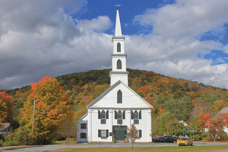
Newfane’s village green. Newfane is one of several quaint small towns in the West River’s watershed.
Often cited as one of New England’s most picturesque villages, the town of Newfane has a well-preserved common with stately historic buildings such as the Windham County Courthouse, which celebrates its 200th anniversary in 2025, two inns that provide accommodations and food for travelers, and three churches. The West River powered the town’s lumber and flour mills during the nineteenth century.
West of Townshend’s spacious village green, the Scott Covered Bridge features an unusual combination of lattice and king’s post frame designs. Also built after the flood of 1869, the triple-span structure became a state historic site in 1955. Significant deterioration, caused in part by infestations of carpenter ants, necessitated an extensive rehabilitation in 2017.
Exacerbated by the valley’s steep funnel-like slopes and high-elevation snowfalls, many other damaging floods have occurred throughout the West River watershed as recently as July 2023. Townshend Lake Dam, one of two flood-control impoundments in the central uplands, mitigates damage to communities on the West and Connecticut rivers. Visitor amenities include overlooks and a seasonal recreational area at Townshend Lake. A fine perspective of the lake, dam, and valley hills rewards hikers on Ledges Trail, a moderately steep 1.7-mile circuit that begins at the recreation area.
In East Jamaica, Route 30 merges with Route 100, a fabled scenic byway that extends for nearly 220 miles along the Green Mountains. Upstream from the nearby confluence with Ball Mountain Brook in Jamaica, the West River courses through a narrow, steep ravine with sections of deep water, boulders, and rapids.
Jamaica State Park encompasses a variety of attractions along this stretch of the river. A picturesque segment of West River Trail winds along the riverbank past Salmon Hole and an overlook at the Dumplings, a cluster of glacial boulders (as of spring 2025 a portion of the trail is closed after a landslide in 2023; see the park website for updates). Deep slow-water pools and shallow riffles provide opportunities for anglers. Atop the adjacent valley ridge, Little Ball Mountain, reached via Overlook Trail, offers westerly views across wooded hills.
On a steep slope at the park’s northern boundary, Cobb Brook plunges 125 feet at Hamilton Falls, one of Vermont’s largest waterfalls. Originally built to provide access from the railroad to West Windham, Switch Road Trail links West River Trail to the falls. For a rewarding day hike, combine the West River, Switch Road, and Overlook trails for a round trip of roughly 6.2 miles.
The valley’s upper flood control project, Ball Mountain Dam impounds the river at a narrow passage on the west side of Jamaica State Park. Biannual water releases in the spring and late September attract hordes of whitewater paddlers. From a gazebo and picnic site along the entrance road, views unfold along the valley to Angel Falls, a dramatic 25-foot cascade on a tributary brook. A segment of West River Trail offers a mostly easy one-mile trek to the falls. See the Spring 2024 issue for information about visiting the region’s waterfalls.
Along the West River’s upper reaches, Route 100 leads through the mountain towns of Londonderry and Weston, which suffered substantial flood damage in 2023—now repaired. Situated at a photogenic pond and waterfall near Weston’s town common, the Weston Mill Museum preserves the valley’s industrial heritage. Originally built in 1785 as a sawmill, the structure houses displays of historical tools and machinery.
Off the main routes, back roads and less-traveled highways provide many additional opportunities for exploration. Some of my favorites include Williamsville Road, which leads to a covered bridge at Newfane’s village of Williamsville and the scenic town of Dover; and Route 121, which loops back to the Connecticut River valley via the Saxtons River.
John Burk is a writer, photographer, and historian from western Massachusetts whose credits include books, guides, and articles in nature and regional publications.
Resources
Friends of the West River Trail
westrivertrail.org/
Retreat Farm/Retreat Meadows
45 Farmhouse Square, Brattleboro, VT
retreatfarm.org/trails-waters
Black Mountain
1112 Rice Farm Road, Dummerston, VT
Visit nature.org and search for Black Mountain Natural Area
Townshend Lake
3845 Vermont Route 30, Townshend, VT
nae.usace.army.mil/Missions/Recreation/Townshend-Lake/
Jamaica State Park
48 Salmon Hole Lane, Jamaica, VT
vtstateparks.com/parks/jamaica
Ball Mountain Lake
88 Ball Mountain Lane, Jamaica, VT
nae.usace.army.mil/Missions/Recreation/Ball-Mountain-Lake