 This article appears in the Summer 2024 issue

Boating the French King Gorge
to Barton Cove
Story and photos by John Burk
Last summer—after water levels finally subsided after prolonged rain—I embarked on an interpretive cruise aboard the Heritage, a tour boat operated by FirstLight’s Northfield Mountain Environmental Education and Recreation Center. The group enjoyed river-level perspectives of attractions such as the French King Gorge and Barton Cove, and views of bald eagles and other wildlife.
Aptly named Riverview Picnic Area, the tour’s starting point lies roughly 5.5 miles upriver from Barton Cove’s north shores at the lower end. Cartop boat access is available at this pleasant park situated on the river’s east bank near the base of Northfield Mountain. Pauchaug Brook Boat Launch, a state-owned facility near the Vermont state line (8.5 miles north of the picnic area), provides opportunities for longer adventures. Nearby Munn’s Ferry Campground, accessible only by boat, offers several tent sites and an Adirondack shelter.
Heading downstream toward the head of the French King Gorge, we passed the intake of the Northfield Mountain hydroelectric pumped-storage facility, which elevates water up to a 300-acre reservoir at the summit. At the gorge’s northern end lies the French King Rock, a giant glacial boulder that once stood prominently in the riverbed before construction of the Turners Falls Dam raised water levels. French officers reputedly named it in honor of King Louis XV during an eighteenth-century territorial claim. Paddlers should stay close to shore to avoid turbulence near the rock.
The Connecticut River scoured the steep-walled French King Gorge, a well-known landmark of western Massachusetts, after Lake Hitchcock drained at the end of the last ice age. The 400-foot-deep chasm lies along the Eastern Border Fault, a geologic fracture that formed the original Connecticut Valley. Stacy Mountain, site of a Nature Conservancy preserve that provides habitat for rare plant and animal species, looms above the west bank. On the east side are 450-million-year-old gneiss rock outcrops that originally were part of the Taconic Mountains. Colorful fall foliage adorns the slopes in October.
Roughly 1.5 miles downstream from Riverview Picnic Area, we cruised beneath the fabled Mohawk Trail Highway’s French King Bridge. Built in 1932, the 786-foot cantilever arch structure comprises three spans and a pedestrian walkway with outstanding views from 140 feet above the river.
At the base of the French King Bridge is the confluence with the Millers River, the Connecticut River’s primary tributary in north-central Massachusetts. Its waters have powered numerous significant industries, including tool companies, paper mills, and sewing machine factories, in upriver towns. Be aware of potentially rough current here during high-water periods.
Downstream from the bridge, the Connecticut River swings abruptly north past the Mineral Hills and west through a narrow section known as Horse Race. Along this stretch are two of the river’s deepest spots, 130-foot-deep French King Hole and 100-foot-deep King Philip’s Abyss. According to geologist Richard Little, both were scoured by waterfalls when the Connecticut River shaped its postglacial course. Approaching Barton Cove, we glimpsed a family of river otters diving around logs, and a great blue heron stalking a wetland.
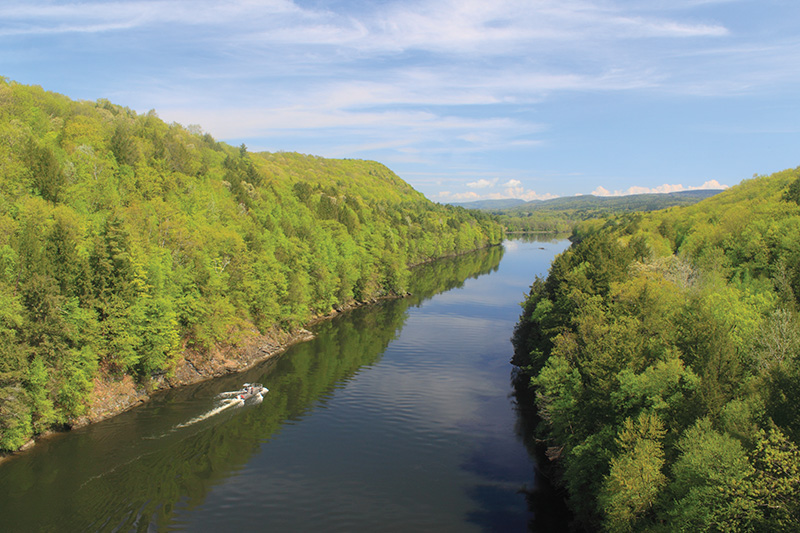
French King Gorge, Connecticut River.
After passing a mile-long sandstone peninsula and a gap called The Narrows, the Heritage entered Barton Cove, a broad pool behind the Turners Falls Dam. The celebrity resident bald eagles obligingly perched in tall trees on the riverbank, staking out fish and waterfowl. Eagles began nesting on diminutive Barton Island in 1989 and have been present since (a storm toppled the original nest tree in 2008, but the eagles rebuilt nearby). The first pair likely came from Quabbin Reservoir where eagles were successfully reintroduced to Massachusetts during the 1980s.
A variety of other birds frequent the cove throughout the year. On this day, mallard ducks, Canada geese, and mute swans shepherded broods of chicks along the water’s edge. Many rare and uncommon species, such as barnacle geese, tundra swans, and Iceland gulls, have been seen in other seasons.
On the aforementioned peninsula’s northwest side, paddlers can explore ancient waterfall pools that formed when the Connecticut River cascaded over the cliffs more than 9,000 years ago. The easternmost, Lily Pond, became connected to Barton Cove after construction of the Turners Falls Dam.
Facilities at Barton Cove include a state boat ramp on the north shore with a concrete launch and ample parking. Cartop boat access is also available at the peninsula, where FirstLight manages a campground, day-use area, and nature preserve with thirty-one tent sites and a picnic area. Canoes, kayaks, and paddleboats can be rented for up to a full day here. Long-distance paddlers may arrange for a free portage around the Turners Falls Dam. A nature trail leads to outcrops and ridges, a former dinosaur track quarry site, and an elevated observation deck at Lily Pond with scenic views across the cove.
At a floating barrier near the Turners Falls Dam that marks the boundary for boaters, accumulated logs and debris stood as evidence of the destructive floods that impacted the watershed in 2023. Heading back to Riverview Picnic Area, we enjoyed different perspectives of the various sights.
The riverboat tours operate three times daily, Thursday to Sunday, from late June through mid-October, weather and river conditions permitting. Tickets may be purchased online in advance (recommended), or at the Riverview Picnic Area dock if space is available. The 12-mile round trip takes 1.5 hours.
Allow roughly two hours (one-way), depending on water levels, for paddling from Riverbend Picnic Area to Barton Cove, plus time to explore and enjoy the various attractions. Motorboat traffic peaks on weekends and holidays, so you may want to plan a canoe or kayak trip accordingly.
John Burk is a writer, photographer, and historian from western Massachusetts whose credits include 15 books and guides and articles in nature and regional publications.
How to Get There
Barton Cove
Directions: From Interstate 91 in Greenfield, take exit 46 and follow MA 2 east for 3.1 miles to the state boat ramp, or 3.5 miles to the Barton Cove Campground and day-use area.
Riverbend Picnic Area
Directions: From the intersection of MA 2 and MA 63 in Millers Falls (1 mile east of the French King Bridge), follow MA 63 north for 2.2 miles. After passing the Northfield Mountain Environmental and Recreation Center driveway, take the next left on Ferry Road and continue 0.2 miles to the entrance at the intersection with Pine Meadow Road.
Helpful Resources
FirstLight: firstlight.energy/stewardship
(tours, boat rentals, and camping information)
Connecticut River Paddler’s Trail: connecticutriverpaddlerstrail.org
Book: The Connecticut River Boating Guide: Source to Sea. Connecticut River Watershed Council, 2007.