 This article appears in the Spring 2024 issue

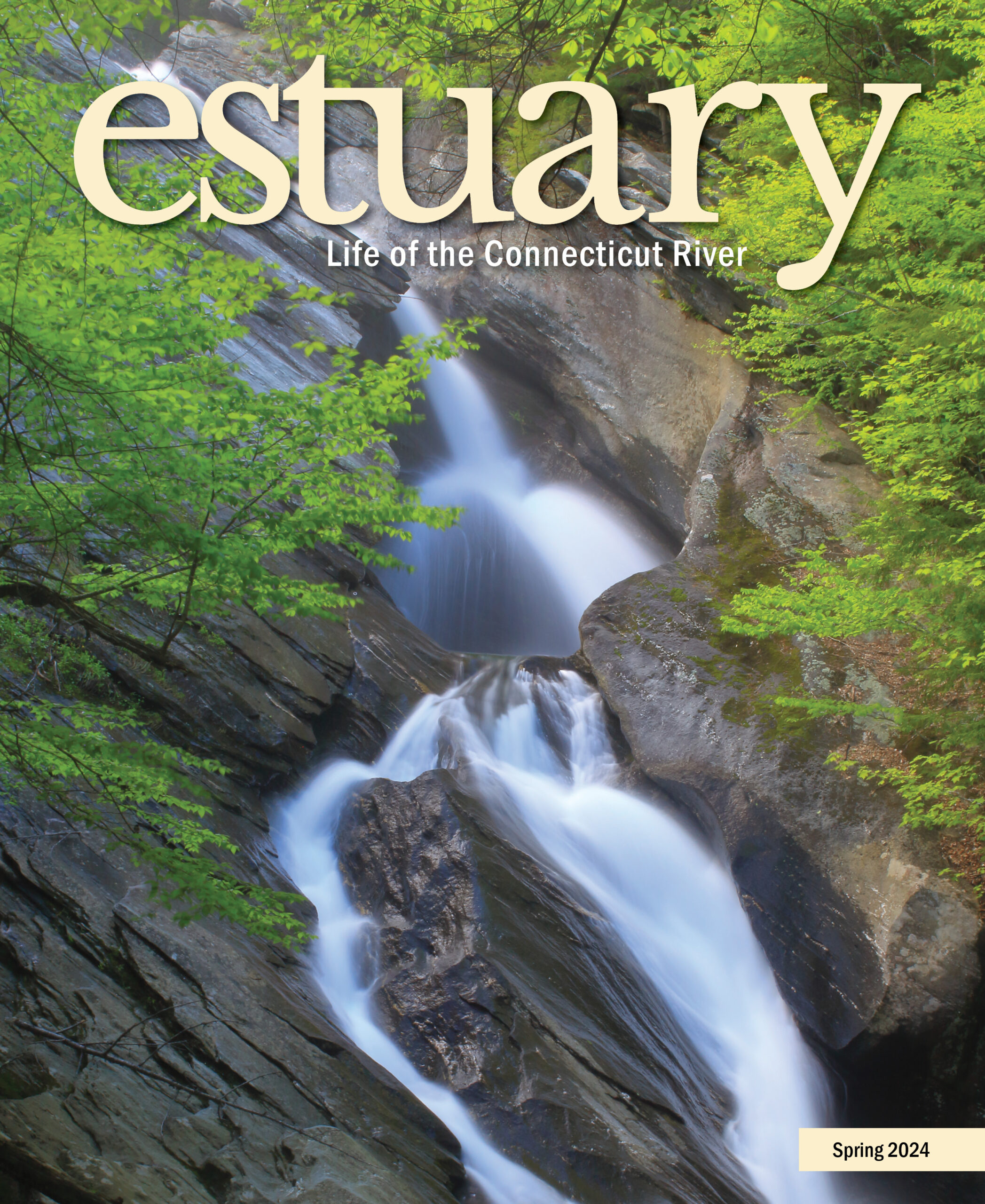
Vermont’s Spectacular Waterfalls
By John Burk
Few things in nature exemplify spring more than a roaring waterfall or stream in a freshly leafed out forest. The Connecticut River’s extensive watershed, which encompasses mountainous regions such as Vermont’s Green Mountains, the Berkshire Hills of Massachusetts, and Connecticut’s northwest highlands, provides an ideal setting for cascades of all shapes and sizes. Below are several of my favorite waterfall hikes in southern Vermont (look for southern New England trails in an upcoming issue).
Mount Ascutney, the Connecticut River Valley’s highest summit at 3,144 feet, hosts several seasonal waterfalls that are especially attractive in spring or after heavy rain. At Crystal Cascade Falls on the southeast slopes, Mill Brook plunges 84 feet over a wide granite ledge. Nearby Little Cascade Falls, on a smaller stream that often dries up in late spring and summer, comprises a series of small drops totaling roughly 60 feet.
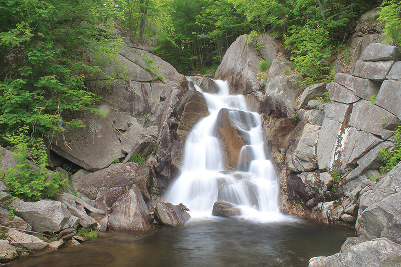
Angel Falls just upstream from Ball Mountain Lake, Jamaica, VT. Image Credit: John Burk
Weathersfield Trail, southernmost of four base-to-summit hiking routes on Mount Ascutney, provides a moderately steep ascent to both waterfalls and several scenic overlooks. From the trailhead on High Meadow Road, follow the white-blazed path for 0.4 miles to Little Cascade Falls. Ascend a wooden ladder to an outcropping and vista and continue to Crystal Cascade Falls at 1.1 miles. Enjoy open southerly views from the crest of the falls. Steep, eroded paths, recommended only for hikers comfortable scrambling on rough terrain, lead to perspectives from the sides of the ledge.
Above Crystal Cascade Falls, the upper portion of Weathersfield Trail passes vistas at Gus’s Lookout and West Peak before reaching the summit at 2.9 miles, where an observation tower provides outstanding 360-degree views of the Connecticut River Valley and Green Mountains. Elevation gain is roughly 550 feet to Crystal Cascade Falls and 2,050 feet to the summit.
On the northeast slopes, Mountain Brook tumbles 60 feet over boulders and smooth rock at Gerry’s Falls. From the entrance on VT 44A, follow the lower portion of Windsor Trail through a meadow and ascend along the north side of Mountain Brook’s ravine. At 0.8 miles (roughly 600-foot elevation gain), a short side path on the left leads to a fine perspective of the falls. Return for a 1.6-mile round trip, or continue to three rocky lookouts and the summit, reached at 2.7 miles.
In the heart of the southern Green Mountains lies Hamilton Falls (as seen on this issue’s cover), one of Vermont’s largest waterfalls. En route to its confluence with West River, Cobb Brook plunges 125 feet past potholes and schist bedrock ledges on the steep valley slope. A designated state natural area encompasses the falls and surrounding forests.
From Jamaica State Park, a popular hiking, camping, and paddling destination, follow West River Trail along a former railroad bed for two miles. At a signed intersection, turn right on Hamilton Falls Trail and ascend Cobb Brook’s ravine on an old switch road, historically used for transportation of passengers and freight from the railroad to West Windham, for approximately one mile. Bear left on a short side path that leads to fine views of Hamilton Falls from the base of the ravine.
To reach the crest of the falls, continue to Hamilton Falls Trail’s upper end at West Windham Road, then turn left and walk along the road for a few hundred feet to a signed path. The full hike gains about 800 feet elevation. (Note: Jamaica State Park suffered extensive flooding damage in 2023; see the park website for trail updates. Limited parking is available on West Windham Road; Ball Mountain Dam is another possible starting point).
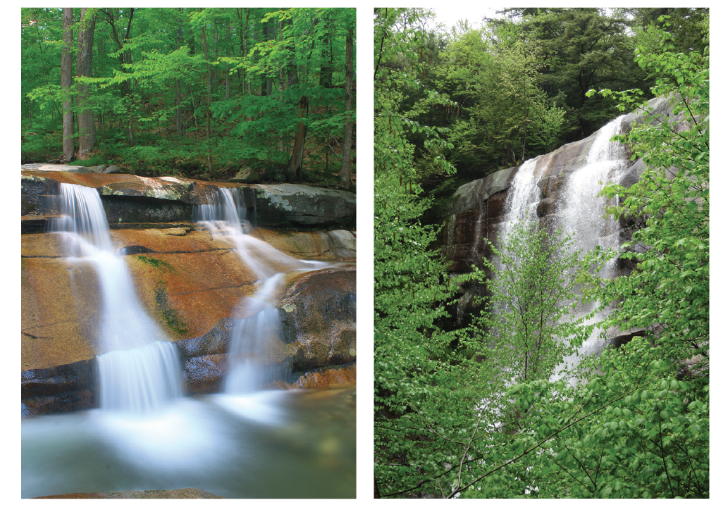
Left: Stickney Brook cascades over Jelly Mill Falls near a former cider mill site, Dummerston, VT. Right: Crystal Cascade Falls on Weathersfield Trail, Mount Ascutney, VT. Image Credit: John Burk (Jelly Mill Falls). Greg Parsons (Crystal Cascade Falls).
Upstream from nearby Ball Mountain Dam, a less-traveled segment of West River Trail leads to picturesque Angel Falls, where a woodland brook drops 25 feet over granite rocks and ledges. A small pool and stone bridge provide diverse perspectives and photo opportunities. The falls lie within the Ball Mountain Lake flood control project, built by the Army Corps of Engineers in the 1950s.
Begin at a picnic area and gazebo on Ball Mountain Lane, where an overlook affords a distant view of Angel Falls. Follow a connecting path downhill for 0.2 miles to the intersection with West River Trail. Turn left on West River Trail, which leads through woods on the valley slope to a footbridge at a cascading stream. At 1.0 miles, reach Angel Falls, a few hundred feet upstream from the banks of West River. The out-and-back route entails approximately 300 feet elevation gain, mostly on the return.
Jelly Mill Falls, named for a former cider mill where jelly was produced, is well worth a short detour for travelers exploring the West River Valley. Informal paths lead to a series of small cascades and granite ledges on Stickney Brook near its confluence with West River. The roadside entrance is on Stickney Brook Road in Dummerston, a few hundred feet west of the intersection with Route 30.
John Burk is a writer, photographer, and historian from western Massachusetts whose credits include 15 books and guides and articles in nature and regional publications.
How to Get There
Ascutney State Park
Directions: For Crystal Cascade Falls, from Interstate 91 in Ascutney take exit 8 and follow VT 131 west for 3.1 miles. Turn right on Cascade Falls Road then take the next left on High Meadow Road and continue 0.4 miles to the Weathersfield Trail parking area. For Gerry’s Falls, from exit 8 take VT 131 east to the intersection with US 5. Follow US 5 north for 1.1 miles then bear left on VT 44A and continue 2.7 miles to Windsor Trail (1.6 miles north of Mount Ascutney State Park’s main entrance).
Website: vtstateparks.com/ascutney.html
Jamaica State Park
Directions: From the intersection of VT 30/VT100 and Depot Street in Jamaica, follow Depot Street north for 0.5 miles, then turn left on Salmon Hole Lane to enter Jamaica State Park.
Website: vtstateparks.com/jamaica.html
Ball Mountain Lake
Directions: From Jamaica center, follow VT 30/VT 100 north for 1.6 miles to the Ball Mountain Lake entrance. Turn right on Ball Mountain Lane and continue 0.7 miles to the picnic area and gazebo.
Website: nae.usace.army.mil/missions/recreation/ball-mountain-lake/
Jelly Mill Falls
Directions: From the intersection of VT 30 and VT 9 at Brattleboro Common, follow VT 30 east for 5 miles. Turn left on Stickney Brook Road and park on the right.
Helpful Resources
Friends of West River Trail: westrivertrail.org
Book: Parsons, Greg, and Kate B. Watson. New England Waterfalls: A guide to more than 500 waterfalls and cascades. Countryman Press, 2019.