
Hidden Gems of the
Wild and Scenic Westfield River
Story and photos by John Burk
Set on a historic railroad line in the scenic Berkshire foothill towns of Middlefield and Chester, Massachusetts, the Keystone Arches Trail offers a fine sampling of the Westfield River watershed’s rich natural resources and history. As I walk along an abandoned railroad bed and old turnpike on the banks of the river’s West Branch, views unfold of cascading streams, rolling valley hills, unbroken forests, and the trail’s namesake, a series of striking nineteenth-century stone arch bridges built as part of the Western Railroad, America’s first mountain railway.
The Westfield River, the Connecticut River watershed’s first National and Scenic River and longest tributary in Massachusetts, drains a largely undeveloped, densely wooded 520-square-mile basin that stretches from the eastern Berkshire Hills to the lower Pioneer Valley. Three major tributaries, the East, Middle, and West Branches, converge in the town of Huntington to form the main stem, which joins the Connecticut River near Springfield. Designated Wild and Scenic segments, established in 1993 and 2004, include 28 miles of the East Branch, 16 miles of the West Branch, 13 miles of the Middle Branch, and 20 miles of headwater tributary streams and brooks. These waterways support diverse fish communities, including trout and other cold-water species, one of the Connecticut River watershed’s largest shad runs, and Massachusetts’s only lake chub population.
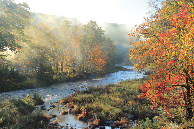
Westfield River with autumn fog rays.
In the words of ecologist Glenn Motzkin, whose work includes surveys of rare plants and invasive species in the watershed, “The Westfield River is widely recognized as one of the highest priorities for biodiversity conservation in southern New England and represents one of the region’s few river basins with relatively intact hydrological and ecologic processes. High concentrations of rare species, exemplary natural communities such as riverside meadows and floodplain forests, and extensive areas of high-quality wildlife habitat and cold-water fisheries highlight its significance.”
From a viewpoint atop an abandoned bridge on Keystone Arches Trail, I pause to take in views of the West Branch, Massachusetts’s longest free-flowing river reach, as it winds past steep hills downstream from headwaters in October Mountain State Forest. Despite rugged terrain, the valley provided the most feasible route across the eastern Berkshire Hills for Western Railroad designer George Washington Whistler. Completed in 1841, the railway, which established a crucial link between Boston and Albany, included ten river crossings on intricately crafted stone arch bridges. Two arch bridges remain in service on an active line, and two abandoned structures were designated as National Historic Landmarks in 2021. A former depot in the nearby center of Chester now houses Chester Railway Station Museum, open seasonally on weekends.
Downstream from the Keystone Arches, Chester-Blandford State Forest encompasses 2,300 acres of wooded hills, cascading brooks, and old mine and quarry sites on the south side of the valley. A mile upstream from its confluence with the West Branch, Sanderson Brook drops 60 feet over steep ledges at popular Sanderson Brook Falls. Less-traveled Goldmine Brook Falls lies within a hidden ravine off Route 20 near the Boulder Park entrance. A lookout atop aptly named Observation Hill, reached via a rugged half-mile ascent from Sanderson Brook Road, offers a fine perspective of the West Branch corridor. Nutrient-rich soils sustain abundant spring wildflowers such as red trilliums, Dutchman’s breeches, and trout lilies...